Thursday, 25 February 2016

Over half way !!!

Completing Route 4 means I have now walked 13 miles - half way !! It's hard to believe we've walked this far, looking on the map I could have cut many corners and probably got to this point in just two walks - but that would be cheating !!

Half way - our walk so far
Saturday dawned quite chilly with the forecast of rain so wrapped up and with umbrellas we made our way to Nuneaton station. Virgin Trains have been absolutely amazing with their support. We would have still done my Challenge but there is no doubt that their sponsorship in providing train tickets has been a real bonus.

Arriving in Euston just a few minutes late due to engineering works we took the familiar route on the Northern Line to London Bridge and then the Jubilee line to Canada Water where we met up with our friends Dave and Agnes who were joining us to walk Route 4.

Canada Water is the opposite side of Surrey Quays to where Route 3 finished but as it was easier to get the tube than spend a lot longer on the bus the first part of our walk was retracing the very end of Route 3, with added interest on the way. Firstly a small cut of water with moorhens swimming around and a water bird we had seen before but unsure of it's name - finding out later it was a coot !

Coot with ultra bright legs (I'm not sure what was in the
water but everything looked ultra violet)
There's lots of building work happening at Surrey Quays around the old docks and canals. At one point we could see into the compound and the foundation work - such a surprise to see an old dock layout which they appear to be preserving.

Old dock being preserved as the rebuilt takes place
All this interest already and we were not even at the starting point - in fact it was a quarter of a mile to the finish point of Route 3. Nothing had changed, but then it was only a month since we'd been. Our friends kindly took the starting photo so for once you can see both of us.

Ready for Route 4 
Off we set - nothing very exciting about this area of London today but as I said before it was once a thriving dock area with many canals, shipbuilding, trade and of course dockers. The area is now known as Rotherhithe but was originally called Redriff and in Anglo Saxon times was where cattle were landed due to it being one of the ancient river crossing points.

Redriff Road curves left following the river, although we could not see the water as there are houses and flats between the road and river, changing into Slater Road passing Surrey Docks Farm although again we couldn't quite see it. The Thames path runs right along the river edge and having had so much fun doing this walk is something we may consider in the future as it would be very interesting to walk riverside.

Above the houses we could see Canary Wharf - it seemed so close, not the other side of the Thames River. Route 5 and 6 takes us round the Isle of Dogs past all the huge sky scrapers - I hope we'll get the chance to look back across the river.

Canary Wharf - incredible to think the River Thames is between the
houses and the skyscrapers.
Slater Road curves again to the left where we discovered Lavender Dock and Lavender Pond Pumping Station. It's now looked after by The Conservation Volunteers but was once a timber pond where timber was floated to stop it drying out. The Pumphouse was build to control the water levels in Surrey Docks - now it's a conservation area enjoyed by local families.

Lavender Pond and the Pumphouse
The locals enjoying the nature reserve
Round the bend even further, we were walking nearly in the opposite direct to our starting route, we passed over Surrey Water and caught a glimpse of the Bascule Bridge at the entrance to Surrey Canal. Andie Byrnes has an amazing blog - A Rotherhide Blog - all about the history of this area. So much to read with so much detail. It is certainly an area Nick and I are keen to know more about and will be reading Andie's blog to find out more.

Bascule Bridge
As you can tell from my bridge photo the weather was turning, in fact we had begun to feel spots of rain. From crossing the canal we were now in Brunel Road and although the Marathon Route continues along here until the road joins with Jamaica Road we did a very slight detour towards the riverside as my legs were ready for a break, and I'd discovered a great pub when researching our walk.

The Mayflower Pub is like stepping back into the 16th Century and was the original mooring point of the Pilgrim Fathers. The pub is superb with it's old wood, cosy rooms, leaded windows, position on the Thames, good food and wine.

Mayflower plaque
Beer costs a little bit more today !!
Leaded windows - the panes have hues of various colours
Signage inside the pub 
Perfect in such a wonderful setting
Enjoying a short rest in an amazing pub.
Just up the road from the pub we found this lovely statute of the Pilgrim Fathers, another part of history that would be interesting to find more about and it's links to this historical part of our capital city.

Pilgrim Fathers
And just outside the pub is the Brunel Museum with it's tall chimney. There is a shaft and tunnel underneath the river from this museum - it's all so interesting. The tunnel was built in 1843 and was the first one to go under the Thames, quite a novelty at the time. The shaft was built so the tunnel could be built.

Brunel Museum 
Back to Marathon walking and we had company .... rain! Not a huge downpour but that persistent rain that soon has you quite wet. Jamaica Road starts at an island - quite a busy island as it's the entrance to Rotherhithe Tunnel. The road goes down the tunnel, turns left to go under the river then turns again to go back up to road height. Why the turns instead of curves - the tunnel was built in the age of horse and cart - when the horses went under tunnel it was important they didn't see the light of the exit too soon or they would bolt. So putting in a bend preventing the horses bolting and causing accidents.

The tunnel entrance is the archway you can just see left of the lamppost 
So many cars queueing to go under the tunnel - to be honest I didn't know it was a road tunnel, I only knew about the Blackwall Tunnel so quite a surprise to discover another. Just before the island we passed the foot entrance - not sure I'd walk under looking at the number of cars queueing, all that pollution.
Foot entrance to Rotherhithe Tunnel
The rain had really started to come down, straight ahead was what is becoming my 'special landmark'. The Shard was the first London iconic building we saw on our first route and we have passed by it every journey so far - there it was again, directly in front of us giving a spot on interpretation of the weather !! It's become a bit of an encouragement sight for me and does make me smile every time I spot it - even in the rain.
The Shard - my walking landmark 
The streets were becoming more built up now with a mixture of old and new (to look old) buildings. Every so often we could see through to the river making us wish even more to return to do the Thames Path. Here's a few of the buildings and views we saw as we continued along into Tooley Street towards Tower Bridge.
Most Holy Trinity Roman Catholic Church 

Shad Thames - used in the film Oliver 
Hop Studios built 1887 - previously a warehouse,
now apartments and Penthouse suite
Jamaica Wharf - Grade II listed building 
 The traffic lights on Tooley Road were a welcome sight as it meant finally a right turn - a mixed turn as the rain was now heading towards us but we were heading straight for Tower Bridge - what a view.
Who wouldn't smile with such an iconic view
 - even if it was raining
Tower Bridge is such a landmark with quite a history too. Not least the controversy in the late 1960s when an American Tycoon bought London Bridge maybe by mistake. Tower Bridge when built was the largest most sophisticated bascule bridge known, bascule is french for see-saw or balance.

Built over 120 years ago Tower Bridge is the landmark that most people associate with London and it's an important part of the London Marathon as crossing the bridge leaves the south bank behind, moves runners onto the north, business side of London and most importantly marks half way - yeah!

Our crossing of the bridge was certainly memorable - and a challenge as my legs hurt, the rain was pouring and I had photos to take !


Such a stunning structure 
Still raining
Tower Bridge through it's arches 
The views from the bridge are amazing - looking east it was a surprise to see how far we'd walked as we couldn't see the curve in the river at all. Looking west the skyline was such a mixture of old and new - oh the history. London really is a beautiful city.

Looking east back towards the starting point of Route 4
London skyline - Tower of London and the Gherkin - centuries apart
Route 4 finished just over the bridge at Tower Hill junction, this will be the start of Route 5 which turns east along East Smithfield towards Canary Wharf. 

Route 4 was another great day, very tiring and I must apologise to our friends as although it was raining I couldn't speed up. We were all still smiling though. 
Still smiling in the rain 
Hubby and I at the end of Route 4
Turning round to look back across the bridge what did I see, my special landmark of course. Disappearing in the cloud but still there at the end of Route 4.

The Shard disappearing in the cloud
To celebrate finishing another 3 miles and more importantly achieving the half marathon we headed towards All Bar One, one of my favourite red wines is Yering Station Shiraz Viognier, full of sour cherries with a kick of spice - the perfect way to sit with Hubby and friends to relax after quite a walk.
Perfect treat at the end of Route 4 
Thank you so much to Virgin Trains, our lovely friends Dave & Agnes and special thanks to my super Hubby Nick. At one stage I wondered if I could do this - even the first bit - and now have to pinch myself that I have actually got to the half marathon mark :)


This is a personal challenge as well as a fundraiser for my four great charities - THANK YOU to everyone who has donated - the total is currently £371 which is amazing!

Tired but happy on the train home 
Please share my blog and donation page Virgin Giving Clare's Challenge 

I would really like to raise £500 by the end of my walk so the more sharing the more chance of a few more donations - thank you - see you again soon for Route 5.

Wednesday, 17 February 2016

Walking in the rain ??

Oh I do hope not but the forecast for Saturday is wet .... and windy ! I'm feeling quite good at the moment and the next few months are quite busy so although it's only been 4 weeks we're going to do Route 4 this Saturday (20th). Thank you again to Virgin Trains for their amazing support.

I do have to plan our walks, not just the route but make sure the days leading up to going and the days following I can rest. The day after each walk I am very slow and need support just walking around the house so if we've walked Saturday then Sunday needs to be a free day :)

Route 4 looks to be a variety of buildings, roads and paths. We'll start back at Surrey Quays and finish on the north side of the Thames just over Tower Bridge.

Route 4 mapped on Google Earth 
I think we'll take the Victoria Line to Green Park and then Jubilee Line to Canada Water - it's a little walk then to where we finished last time but not really worth taking the bus. The Transport for London web site has been so useful to find our way to each starting point - we tend to see what buses are around for our return journey, it's easier for me to sit on a bus than go up and down lots of underground stairs at the end of our day.

As you can see on the map our route takes us round the loop of the Thames, along Jamaica Road and finally across Tower Bridge.

We'll be pausing along the way for a sit down and a bit to eat - last time we didn't stop mid-way, I need to. I've spied two pubs which both look very inviting - The Salt Quay and The Mayflower - so we'll see how I feel when we nearby.

The last bit of our walk will be the most exciting - we've been around Tower Bridge before but never approaching it from the east. The forecast is rain but I have my fingers crossed that the sun will shine for our river crossing !!

Route 4 finishes just the other side of the bridge, perfect for having a sit down in once of the lovely restaurants in St Katherine's Dock.

I'm really looking forward to being able to say we're half way !!

Thank you to everyone who has donated and/or shared my blog, it is really appreciated, the more people read my blog the more awareness there is for my four charities. If you wish to add a donation there is a link at the top right of my blog - thank you.

Monday, 1 February 2016

Maze Hill to Surrey Quays - Route 3 completed

Saturday 23rd January saw us up early to catch the 9.05 train to London - I am so grateful to Virgin Trains for their support in my Challenge, their offer of transport has been a huge help, thank you. 

It was a very chilly start and at one point visibility out of our pendolino window was zero as we were suddenly in thick fog. Thankfully the sun was shining in Euston and the morning chill disappearing. 

Our journey to the start of Route 3 meant a quick hop onto the Northern Line to London Bridge. We seem to be visiting this station on most of our visits. Changing to the overground station we had a fantastic view of The Shard whilst waiting for our train to Maze Hill. There are many places Hubby and I want to visit once my Challenge is complete - The Shard being one of them. 

Beautiful view of The Shard from the platform at
London Bridge overground station
It was a short walk from the station to Trafalgar Road (A206) and the finish point of Route 2. It seemed strange to be back in the place we left in late November.

Ready to start Route 3
The biggest problem on my Challenge - apart from my physical slowness & progressive fatigue as the journey progresses) - is being distracted by the buildings around. Both Hubby and I are fascinated by the history of London and the places we are walking through.

Before I took a step to start Route 3 I spotted a very interesting chimney straight in front of me on Old Woolwich Road (the original main road).
Fascinating chimney which we later discovered is part
of Greenwich Power Station
Back on Trafalgar Road we set off - another 3 miles - but after about 3 steps we stopped again, oops! Hubby and I also share a love of wine, not just drinking it but learning and discovering about our favourite drink. I host a wine forum Cuvรฉe Reserve and have a wine/travel blog Aimetu's. That being said we could not walk past without popping into Theatre of Wine with it's amazing window display.

Theatre of Wine - Trafalgar Road
Very clever window display 

There were so many lovely wines and an amazing table made of old wine crates, I'd love one at home. I spotted a very nice bottle, Jean Paul Balland Sancerre 2014, my favourite wine but stayed on the shelf as extra weight for this Challenge is not allowed.

A little further, but not far, we discovered the main part of the Greenwich Power Station. I had seen the chimneys from the bus stop at the end of Route 2 being attracted to their octagonal shape. Up close this time we discovered four chimneys, although at this stage we did not know this was a power station or that the other small building was connected to it.

Octagonal chimneys of Greenwich Power Station 
Time to start walking in the now warm sunny weather; it was lovely strolling (I don't walk very fast) along through Greenwich ..... and more distractions. What an amazing array of architecture - the Old Naval College with its stunning domes and ornate gates, the Royal Observatory on the hill and the wonderful Cutty Sark. Half a mile of walking through some of the most historic places with the most amazing views, our photos tell it all. 

The Royal Observatory on the hill with the very important Meridian Line
Old Navel College's two domes towering over the Thames
Impressive gates with their naval emblems
The Cutty Sark in glorious sunshine 

The Cutty Sark's figure head - who's reflection is that taking a photo? 
Just by the Cutty Sark is the entrance to the Greenwich Tunnel which is a foot tunnel taking you right under the Thames to the Isle of Dogs and was used by the dock workers living on the south side to get to work on the north, a quicker way and more reliable way to get to work than taking the ferry. In the past we have walked the tunnel from the Isle of Dogs to Greenwich.
Greenwich Tunnel entrance
All this walking was very tiring and so we decided to take a break before going any further; just half a mile I hear you cry but in reality I'd been on my feet since leaving Euston, up and down steps on the underground, getting to the start as well as the first half mile of sightseeing walking. So we paused at The Spanish Galleon in Greenwich for a coffee, and a chance for my lovely supportive Hubby to try Shepherd Neame beer from the tap instead of bottled. A lovely pub which has a fish and chip shop inside! It also has a very impressive wine rack - another idea for home maybe. 

The Spanish Galleon's wine rack
It was in the pub we discovered a great little newspaper The Greenwich Visitor and to our surprise and joy it had an article about the chimneys which is how we discovered it was the power station. The newspaper is available online and its map shows the south gate of Greenwich Park where the Marathon (and our Route 1) starts, it clearly shows that we're back level with where we started after doing a six mile trip round Carlton and Woolwich. 

Map of Greenwich
Refreshment stop over we continued through Greenwich village onto Creek Road (A200) the original A2 and old Watling Street. We were both quite keen to walk this road as although now it is mainly new flats and businesses we would be walking over a lot of history. 

Just as we got going we spotted Up The Creek Comedy Club - a very quirky building. 
Up the Creek Comedy Club 
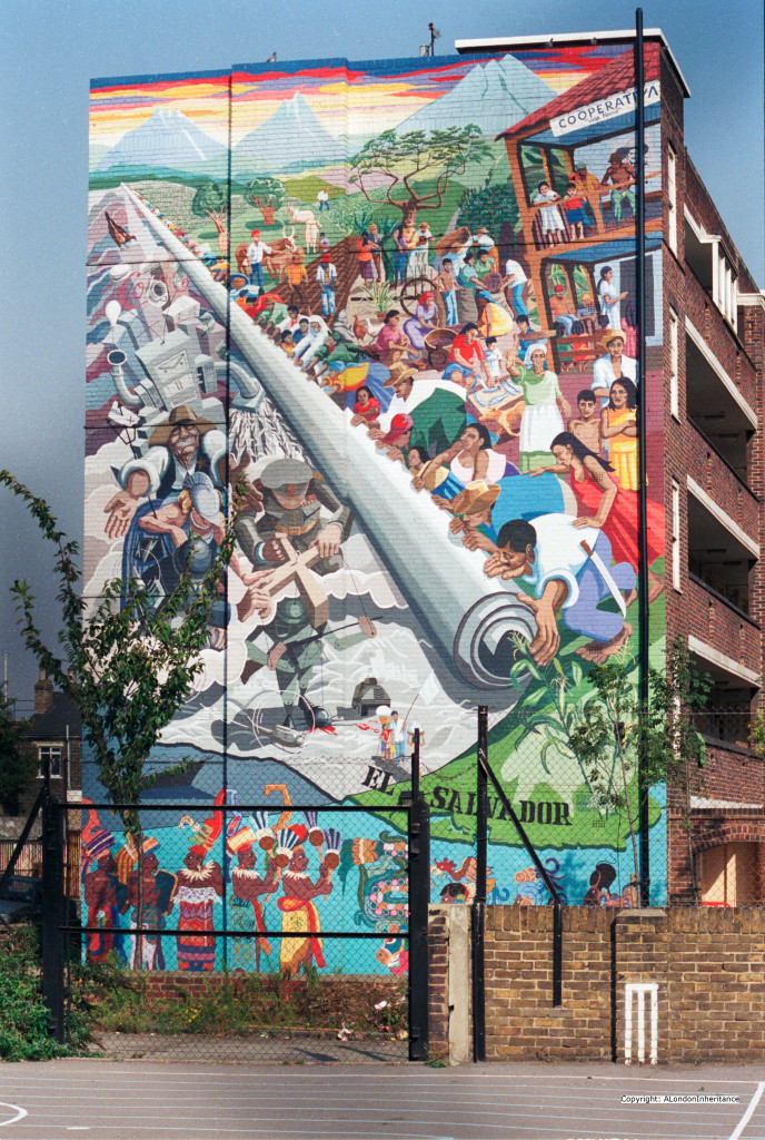
A little further along on the other side of the road I spotted a mural looking very tired but still clear enough to make the image understandable - this extract explains its history;

The mural shows El Salvador in Latin America. A country that was going through considerable violence and turbulence throughout the 1980s following a coup d’รฉtat in 1979.
The mural appears to represent the idyllic cooperative movement rolling back the military and industrial complex back into the sea.The mural is still there, although much faded. The location is the side of Macey House, Horseferry Place, Greenwich.
As we saw it 
As it was when first painted
There are many paintings and other murals around London, we come across quite a few on our walk. The London Mural Preservation Society has a great  online map showing where they are.

Creek Road got its name from Deptford Creek - there is so much history around the river Ravensbourne as far back a references to Julius Caesar. Hubby is very interested in Samuel Pepys and John Evelyn both of whom knew the area, in fact John Evelyn's house was just up the road and the road itself changes its name to Evelyn Street. There is far too much history for me to add to this blog so here's a few photos that show some history still stands between the modern structures.

Deptford Creek as it is today
History Trail plaque

Deptford Fire Station 1903
Evelyn Street with a few old house -
modern London looms int he background
I was just thinking there was nothing else interesting when we saw this
Clare Villas !!!
Evelyn Street changed into Lower Street, it was odd to think of it being the original route to Kent, the Watling Street A2. The north part of the Watling Street, A5, runs right along our town. So much history beneath our feet. This was a long stretch with no pausing places until we arrived at Surrey Quays but as we only had a short distance to the end we decided to keep going to the end. 

As we turned into Surrey Quays there was another mural - this was a Docker's Shelter and depicted their life. 


The Marathon route does a bit of a loop now amongst the retail buildings but not shop fronts so no window shopping distractions. Turning left we wandered along, then right and right again, slow walking now and quite looking forward to the end, coming back to the road we'd just left only a few yards on - the short cut looked very inviting but we stayed 'en route'.

We ended Route 3 by an old canal cutting, now a beautiful walk/park. All the area around Surrey Quays and Rotherhithe was once full of canals and docks, again more history. 

Finish - Route 3 - thank goodness for my Dad's pole 
The red arrow shows where we were with the path going north
 - the dock is still there 
Following the old canal we walked under the road towards the dock and The Moby Dick pub for our well earned rest stop. The walls of the underpass clearly showed how it was once the canal - very strange to think we would have been underwater with big lock gates ahead of us.

The walkway that was once a canal 
Evidence of the old lock gates and canal workings 
The Moby Dick sits on the edge of the dock and did make a lovely final stopping point. A Fuller's pub so different beer to our first stop in Greenwich.

 Fuller's pub - final stop
My well deserved end of walk treat 
Dad's pole enjoying the view over Greenland Dock
This 3 miles was quite a toughie - although it was one road, no hills, it was a long slog and because we had no resting stops I walked 2.5 miles continuous, the pace slowing even more as we reached the end. I used Map my Walk to trace my steps but it logged the shortest points from our stops and the report states 2.8 miles in 18 minutes - oh if only !!

Map my Walk report 
As always thank you to everyone who has supported my Challenge - another donation was made as I was walking which was a real boost. We are not walking along rattling buckets just taking a stroll in our own way.

The fundraising currently stands at £371 which is amazing - please share the link to my blog so others can read about our travels, it is all great fun and the finish line will be a great achievement for me and a bit of help for others !!

Route 4 starts at Surrey Quays and ends on the north side of the Thames just over Tower Bridge, hopefully mid February legs and weather permitting.


Huge thanks to my lovely Hubby Nick 

Without his support, not just his arm on the way, I would not have been able to even attempt this - to be honest I didn't think I would be feel so excited that we are :)

Friday, 22 January 2016

Off again - route 3

Tomorrow is our first walk of 2016 - I'm quite excited to be off again although my legs are not 100% and I have a feeling it will be a slow stroll as opposed to a slow walk.

Virgin Trains have again been so supportive and have sent through our tickets. Our train leaves Nuneaton at 9.05 so a fairly early start to get to the station. I've looked at our London travel and it looks as if we'll need the Northern Line to London Bridge (another chance to stand under The Shard) and overground to Maze Hill which is where we finished last time. 

Map of Route 3 - starting bottom right and ending top left 
Our journey is again along a main road - the A200. Our start is very exciting as we'll be in Greenwich walking past all the old historic buildings and near the Royal Observatory. I do hope I don't get too distracted taking photos and being tempted off route too much. 

We get to walk around the outside of the Cutty Sark before going through Greenwich itself before turning onto the A200 - lots to see and hopefully a quick cuppa too. 

This area of London is very historical - my lovely Hubby is very interested in Samuel Pepys and John Evelyn and this area has some connection. 

Our route using Google Earth 
There's a bit of a loop for the last bit and I'm sure it will seem a long way to get back to the same road. It's around Surrey Quays which is a large retail area and hopefully a good stop for another caffeine top up. 

I am so very grateful to everyone who has donated - the total so far is now  ** £341**
and with Gift Aid that amounts to  over £400


So off we go - my walking pole is ready - I just need to keep reminding my legs that they have an important job to do tomorrow. 

Thank you for all your support - don't forget to pop back next week to see our photos and read about our adventure. 

Monday, 4 January 2016

2016 is here

The festive season was good if a little busy with lots of driving and not much drinking. 

My legs decided yesterday that they would stop - they have been giving me issues for a while but have kept going. Unfortunately yesterday my body screamed 'rest' - funny how it knew the festivities were over. 

Anyway today is slightly better, I am not holding onto the furniture to get round the house and the stairs don't seem so steep. I'm going to try a swim tomorrow but if that puts them back it will be time to contact my MS Nurse - I should really chat with her as my legs have not been good for a while. 

I'm still determined to do my next three miles this month - sometime after the 10th, legs permitting. 

I'd just like to add a huge THANK YOU to my friends and family who made some donations over Christmas. The total now is: 

£341 ๐Ÿ˜˜๐Ÿ˜˜