Saturday 23rd January saw us up early to catch the 9.05 train to London - I am so grateful to
Virgin Trains for their support in my Challenge, their offer of transport has been a huge help, thank you.
It was a very chilly start and at one point visibility out of our pendolino window was zero as we were suddenly in thick fog. Thankfully the sun was shining in Euston and the morning chill disappearing.
Our journey to the start of
Route 3 meant a quick hop onto the Northern Line to London Bridge. We seem to be visiting this station on most of our visits. Changing to the overground station we had a fantastic view of
The Shard whilst waiting for our train to Maze Hill. There are many places Hubby and I want to visit once my Challenge is complete - The Shard being one of them.
 |
Beautiful view of The Shard from the platform at
London Bridge overground station |
It was a short walk from the station to Trafalgar Road (A206) and the finish point of
Route 2. It seemed strange to be back in the place we left in late November.
 |
| Ready to start Route 3 |
The biggest problem on my Challenge - apart from my physical slowness & progressive fatigue as the journey progresses) - is being distracted by the buildings around. Both Hubby and I are fascinated by the history of London and the places we are walking through.
Before I took a step to start Route 3 I spotted a very interesting chimney straight in front of me on Old Woolwich Road (the original main road).
 |
Fascinating chimney which we later discovered is part
of Greenwich Power Station |
Back on Trafalgar Road we set off - another 3 miles - but after about 3 steps we stopped again, oops! Hubby and I also share a love of wine, not just drinking it but learning and discovering about our favourite drink. I host a wine forum
Cuvée Reserve and have a wine/travel blog
Aimetu's. That being said we could not walk past without popping into
Theatre of Wine with it's amazing window display.
 |
| Theatre of Wine - Trafalgar Road |
 |
| Very clever window display |
There were so many lovely wines and an amazing table made of old wine crates, I'd love one at home. I spotted a very nice bottle, Jean Paul Balland Sancerre 2014, my favourite wine but stayed on the shelf as extra weight for this Challenge is not allowed.
A little further, but not far, we discovered the main part of the
Greenwich Power Station. I had seen the chimneys from the bus stop at the end of Route 2 being attracted to their octagonal shape. Up close this time we discovered four chimneys, although at this stage we did not know this was a power station or that the other small building was connected to it.
 |
| Octagonal chimneys of Greenwich Power Station |
Time to start walking in the now warm sunny weather; it was lovely strolling (I don't walk very fast) along through
Greenwich ..... and more distractions. What an amazing array of architecture - the
Old Naval College with its stunning domes and ornate gates, the
Royal Observatory on the hill and the wonderful
Cutty Sark. Half a mile of walking through some of the most historic places with the most amazing views, our photos tell it all.
 |
| The Royal Observatory on the hill with the very important Meridian Line |
 |
| Old Navel College's two domes towering over the Thames |
 |
| Impressive gates with their naval emblems |
 |
| The Cutty Sark in glorious sunshine |
 |
| The Cutty Sark's figure head - who's reflection is that taking a photo? |
Just by the Cutty Sark is the entrance to the
Greenwich Tunnel which is a foot tunnel taking you right under the Thames to the Isle of Dogs and was used by the dock workers living on the south side to get to work on the north, a quicker way and more reliable way to get to work than taking the ferry. In the past we have walked the tunnel from the Isle of Dogs to Greenwich.
 |
| Greenwich Tunnel entrance |
All this walking was very tiring and so we decided to take a break before going any further; just half a mile I hear you cry but in reality I'd been on my feet since leaving Euston, up and down steps on the underground, getting to the start as well as the first half mile of
sightseeing walking. So we paused at
The Spanish Galleon in Greenwich for a coffee, and a chance for my lovely supportive Hubby to try Shepherd Neame beer from the tap instead of bottled. A lovely pub which has a fish and chip shop inside! It also has a very impressive wine rack - another idea for home maybe.
 |
| The Spanish Galleon's wine rack |
It was in the pub we discovered a great little newspaper
The Greenwich Visitor and to our surprise and joy it had an article about the chimneys which is how we discovered it was the power station. The newspaper is available online and its map shows the south gate of Greenwich Park where the Marathon (and our
Route 1) starts, it clearly shows that we're back level with where we started after doing a six mile trip round Carlton and Woolwich.
 |
| Map of Greenwich |
Refreshment stop over we continued through Greenwich village onto Creek Road (A200) the original A2 and old Watling Street. We were both quite keen to walk this road as although now it is mainly new flats and businesses we would be walking over a lot of history.
 |
| Up the Creek Comedy Club |
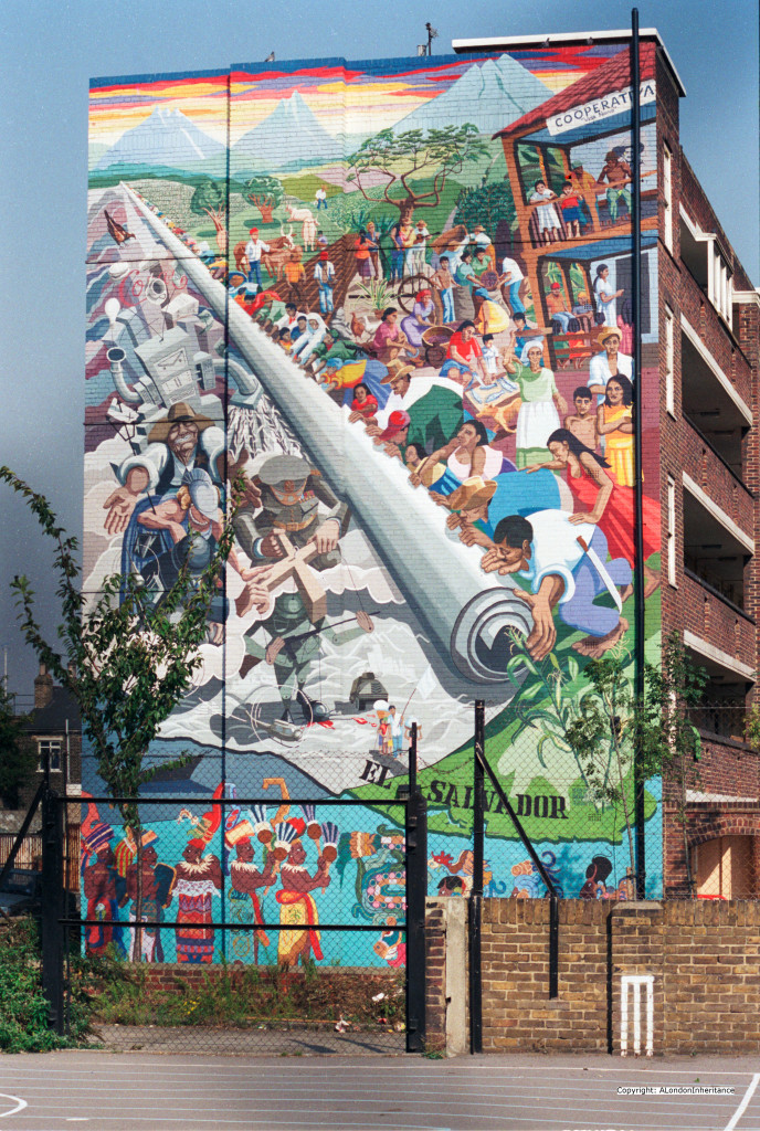
A little further along on the other side of the road I spotted a mural looking very tired but still clear enough to make the image understandable - this extract explains its history;
The mural shows El Salvador in Latin America. A country that was going through considerable violence and turbulence throughout the 1980s following a coup d’état in 1979.
The mural appears to represent the idyllic cooperative movement rolling back the military and industrial complex back into the sea.The mural is still there, although much faded. The location is the side of Macey House, Horseferry Place, Greenwich.
 |
| As we saw it |
 |
| As it was when first painted |
There are many paintings and other murals around London, we come across quite a few on our walk.
The London Mural Preservation Society has a great online map showing where they are.
Creek Road got its name from
Deptford Creek - there is so much history around the river Ravensbourne as far back a references to Julius Caesar. Hubby is very interested in Samuel Pepys and John Evelyn both of whom knew the area, in fact John Evelyn's house was just up the road and the road itself changes its name to Evelyn Street. There is far too much history for me to add to this blog so here's a few photos that show some history still stands between the modern structures.
 |
| Deptford Creek as it is today |
 |
| History Trail plaque |
 |
| Deptford Fire Station 1903 |
 |
Evelyn Street with a few old house -
modern London looms int he background |
 |
I was just thinking there was nothing else interesting when we saw this
Clare Villas !!! |
Evelyn Street changed into Lower Street, it was odd to think of it being the original route to Kent, the Watling Street A2. The north part of the Watling Street, A5, runs right along our town. So much history beneath our feet. This was a long stretch with no pausing places until we arrived at
Surrey Quays but as we only had a short distance to the end we decided to keep going to the end.
As we turned into Surrey Quays there was another mural - this was a
Docker's Shelter and depicted their life.
The Marathon route does a bit of a loop now amongst the retail buildings but not shop fronts so no window shopping distractions. Turning left we wandered along, then right and right again, slow walking now and quite looking forward to the end, coming back to the road we'd just left only a few yards on - the short cut looked very inviting but we stayed 'en route'.
We ended Route 3 by an old canal cutting, now a beautiful walk/park. All the area around Surrey Quays and Rotherhithe was once full of canals and docks, again more history.
 |
| Finish - Route 3 - thank goodness for my Dad's pole |
 |
The red arrow shows where we were with the path going north
- the dock is still there |
Following the old canal we walked under the road towards the dock and The Moby Dick pub for our well earned rest stop. The walls of the underpass clearly showed how it was once the canal - very strange to think we would have been underwater with big lock gates ahead of us.
 |
| The walkway that was once a canal |
 |
| Evidence of the old lock gates and canal workings |
The Moby Dick sits on the edge of the dock and did make a lovely final stopping point. A Fuller's pub so different beer to our first stop in Greenwich.
 |
| Fuller's pub - final stop |
 |
| My well deserved end of walk treat |
 |
| Dad's pole enjoying the view over Greenland Dock |
This 3 miles was quite a toughie - although it was one road, no hills, it was a long slog and because we had no resting stops I walked 2.5 miles continuous, the pace slowing even more as we reached the end. I used Map my Walk to trace my steps but it logged the shortest points from our stops and the report states 2.8 miles in 18 minutes - oh if only !!
 |
| Map my Walk report |
As always thank you to everyone who has supported my Challenge - another donation was made as I was walking which was a real boost. We are not walking along rattling buckets just taking a stroll in our own way.
The fundraising currently stands at £371 which is amazing - please share the link to my blog so others can read about our travels, it is all great fun and the finish line will be a great achievement for me and a bit of help for others !!
Route 4 starts at Surrey Quays and ends on the north side of the Thames just over Tower Bridge, hopefully mid February legs and weather permitting.
Huge thanks to my lovely Hubby Nick
Without his support, not just his arm on the way, I would not have been able to even attempt this - to be honest I didn't think I would be feel so excited that we are :)


Well done Clare.
ReplyDeleteMy brother and SIL are off for tea at the Shard this month, it was a Christmas gift and they will be celebrating their wedding anniversary there.
xxx
A great record of your walk, Clare. I admire what you are doing, especially given that it is so exhausting for you.
ReplyDelete